
La Scia
Starting point: St. Pierre de Chartreuse Difficulty: 2 Ascent: 920 m Time: 6½ hrs Quality: **
La Scia (1,791 m) is the hill overlooking St. Pierre de Chartreuse which has been exploited for skiing, and at first glance it doesn't seem to have much going for it. The west side is dominated by pistes and skiing paraphernalia, and from the south-west the top appears to be dominated by a building. Appearances can be deceiving, however, and this walk is surprisingly good. It is by no means a wilderness walk, but although starting in the centre of St. Pierre de Chartreuse it soon leaves the hurly burly of the town behind, and it only makes a nodding acquaintance with the skiing area. The summit itself is surprisingly isolated, and the views from it are outstanding. This walks descends the ascent route (see map).
From the Place de la Marie in St. Pierre de Chartreuse take the road to Perquelin and after some five minutes, past the last house, a signed footpath will be found on the left. This starts as an old track which once served some now ruined houses. After 10 minutes there is a signed junction, with our path going up to the right. This starts steeply, but soon morphs into a beautifully constructed path that zig-zags up through the woods, with the sounds of the town soon being replaced by birdsong.
After about 40 minutes, a second junction is encountered, with a way towards Les Essarts off to the left, and La Scia signposted to the right. The path now becomes a little rockier, traversing above the Perquelin valley close to the top of the Rochers du Mollard. At times the path follows a ledge with steep drops on the right, but it is wide enough and there are cables on the more exposed parts. It is a splendid section which ends when another junction is reached at Les Mollard. Again we keep right. Ignoring the next junction coming in from the left, a forestry track is soon met. We turn left and pick up the continuation of the path after about 30 metres. In another 15 minutes or so yet another junction is met at the base of an alpine meadow. Make a note of this junction, as it is easy to miss it on the return. We turn right.
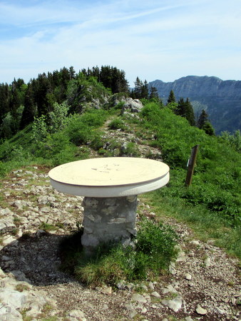
From here the path traverses along the southern slopes of La Scia through woodland and alpine meadows for about 15 minutes where on gets superb views into the Cirque Sans Nom, until a junction is reached at the end of a broad meadow. The path straight on goes to the Cabane de Bellefont, but we head up along long sweeping zig-zags. The meadow doesn't look as if it is grazed now, and it is becoming overgrown with briers and other shrubs, but it still has a wealth of flowers. After 20 minutes we reach a col, and look down on the ski station, but rather than becoming too closely involved with it, we quickly leave it behind by continuing up a nice section of steep rocky ridge to Bec de la Scia. Here a stone table serves as a viewpoint indicator, and being surrounded by Dent de Crolles, Grand Som, Charmant Som and Chamechaude, the view is well worth the climb. However, we are not yet at the top. Continue north along the ridge - this section is great fun - narrow in places, rocky with a number of easy scrambles, and the route isn't always obvious. After fifteen minutes or so a flatter open area is entered, with the summit cross near the far end on a foundation of lapiaz - a fine place for lunch.
Unfortunately, there is no option but to return by the way we came up (although if one has two cars available, it is possible to continue along the ridge and finish up at Col du Cucheron). It's no hardship, however, as it's a lovely walk, and well graded. It has no difficulties apart from identifying the path that leads down from the base of the alpine meadow. An electricity pylon just beyond the junction is a good reminder.