
Dent de Crolles - Pravouta
Starting point: Col du Coq Difficulty: 1 Ascent: 326 m Time: 2 hrs Quality: **
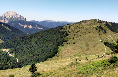
Pravouta is the small top 1 km north of col du Coq. It is popular with families as its ascent is very easy, and the views are excellent - to the east, the cliffs of Dent de Crolles, and to the west, Chamechaude and Charmant Som. Unfortunately, the standard ways up have always seemed rather boring and busy, but if you want a very short day, this little-used alternative to the two voie normales is good fun. It basically goes straight up the south ridge from col du Coq (map) on an old route that is now seldom used.
Park at the top of the col du Coq (1434 m grid ref. UTM 31T 72238 50205).
From the car park, the GR9 enters the wood on its way to Dent de Crolles. Immediately, inside the wood, is a wooden fence. Climb over this at its far end, and find a route up hill in the forest as best you can. An old path is occasionally found, but in general keep close to the ridge which is regularly marked by white rectangles of paint on trees - commune boundary markers. You will encounter obstacles - fallen trees, outcrops of rock, etc. which need negotiating, but always make your way back to the ridge as soon as possible.
After half an hour we start to leave the forest behind and enter the alp. The continuation of the ridge can be seen to be well defined, but again minor obstacles are encountered, this time in the form of almost impenetrable vegetation, but persevere in keeping close to the ridge, and don't be tempted by the sheep tracks traversing the hill. A false summit holds our attention for some time, but the real summit is only a few metres further on, where you will meet with the family groups who ascended by one of the other two routes.
The views are good. The cliffs of Dent de Crolles do tend to hold the attention, but to the other side one can see down to Martinière and St. Hughes.
Technically speaking, the high point of this massif by 8 metres is Roc d'Arguille, which is a further 30 minutes along the ridge. In practice, the top of this is dominated by stinging nettles and the smell of sheep urine, and can be unpleasant.
Continue along the ridge to a sign-posted col. There are two ways back to the car - one via the col des Ayes to the east, and one by the Pravouta pastures to the west. The choice is yours. Both are well sign-posted. We tend to return by the col des Ayes, as it makes a more satisfying circuit, and is not as well frequented by families.