
l'Aup du Seuil - Tour of the Cirque St. Même
Starting point: Cirque de St. Même Difficulty: 2 Ascent: 500 m Time: 3 hrs Quality: ***
The waterfalls of the Cirque de Saint Même are a popular destination described in every Chartreuse guide book - and justifiable so with its three spectacular waterfalls in an exquisite location. This, however, extends the standard walk to visit the Grotte du Guiers Vif, which raises both the grade and the interest. Much of the route is covered elsewhere in this guide, but this is a shorter walk, suitable for a shorter day. The route (map) starts of at the base of Cirque de St. Même; climbs to the Guiers Vif resurgence and cave via the waterfalls, and returns on the other side of the river.
The Cirque de St. Même is some four kilometres to the south-east of St. Pierre d'Entremont, at the end of the D43E. The local commune has provided a large car park a couple of hundred yards before the meadows in front of the cirque, and vehicles can no longer drive into this little piece of paradise. The area is understandably a honey pot attraction for day visitors, and is best avoided during peak times, when a charge of €4.50 (2023) is made for car parking to help stem the tide.
From the car park (860 m, grid ref. UTM 31T 72625 50316), follow the continuation of the tarmac road through the forest. You will soon enter an area of flat meadows and forests, with the river running along a wide shingle bed. There is a chalet hotel here, and a small bar offering refreshments. Ahead are the cliffs of the cirque, with the river resurging from a couple of springs half way up, before immediately plunging over a double waterfall. Just beyond the buvette is an information notice board, where you can get your bearings. Our walks starts on the obvious path going up towards the forest, following the signposted Sentier des Cascades.
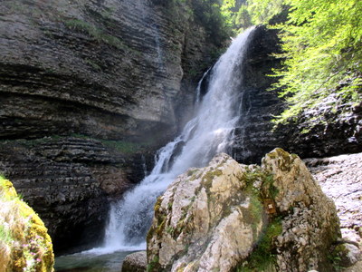
On the way up the zig-zags, a viewing platform allows us to peer through the trees at the first of the three waterfalls - the Cascade d'Isolée. We will be getting a better view of this later in the walk. Continuing on up, a junction is reached with the Sentier des Cascades descending down to the Grande Cascade. That will be our descent route.
Continuing uphill, we turn right at a second junction after a couple of minutes, and drop down to a scree slope beneath the top waterfall, le Cascade de la Source, which is particularly impressive in wet weather. As its name implies, it is situated directly below the springs of the Guiers Vif resurgence.
The Guiers Vif resurgence is the largest in Chartreuse, and the cave entrance above it is, without doubt, the most spectacular in the massif. The entrance area is made up of three sections. First, there is the resurgence platform where up to four springs emerge depending on the water flow, from which there are fine views down the valley. Above that a large natural tunnel leads into The Vestibule, which is a 70 metres section open to the sky between the tunnel and the cave, and may be part of the original cave which has since collapsed.
Note: The next two paragraphs describe an energetic route (Grade 2) to the Guiers Vif cave which is not accessible when the stream level is high. The entrance can be reached more sedately by returning to the main path, and continuing uphill past a rock shelter and some cut steps to another junction. Turning right leads to a rocky section which is descended with the help of a chain to finish on the arête overlooking the cave.
From the scree slope by the waterfall, you can make your way up to the resurgence platform by climbing up in the corner of the rock wall with the help of some iron work (Difficulty 2), and following a rising traverse which emerges on the resurgence platform, which is a fine place to enjoy breakfast.
When water levels are reasonable, you can make your way through the impressive tunnel with the help of some chains, into The Vestibule. Once through the tunnel, make your way up the wide ledge on the right onto an arête. Sometimes, however, there are deep pools barring progress through the tunnel, when it is necessary to retreat back to the main path, and follow that round to the right along the Pas Ruat to the same place.
From the vantage point of the arête above the tunnel, you get a fine view of the entrance to the cave.
You can make your way easily down into The Vestibule, and towards the 30 metre wide, 10 metre high entrance. This cave is impressive, and provided that you have adequate lighting, and there is no flowing water apparent, well worth a 30 minute visit. As in all caves, you do need to take care. Here, the entrance ledges are a little slippery, and there are some pools of water that need traversing around. The passages are also large, so you need to keep your bearings. However, you will find a map attached, which has been adapted from one made by Lancaster University Speleological Society in 1969.
Once in the railway tunnel-type entrance passage, you will see that the passage divides into two, with an impressive 6 metre high pillar in the passage straight on. Keep to the ledge on the right to avoid the pool, and traverse round into the passage on the left. After fifty metres of easy going, the passage turns sharp right, with a smaller continuation straight on. It's worth having a look straight on - there is a low passage with a veritable gale blowing out. This eventually leads into a river passage and an alternative entrance from the plateau high above.
The main passage continues for a hundred metres to a junction in a large chamber. If you peer to the right, you will see daylight along the other passage from the entrance. Make a note. You can then follow a series of very large chambers for a further 100 metres before the passage starts to drop down a boulder slope into the main sump, after which the passage continues underwater. Make your way back carefully to the junction of the two entrance passages, and take the left one this time. The entrance pillar is within 30 metres. There are other accessible passages, totalling well over a kilometre in length, but these are not for casual exploration and should be avoided.
Having visited the cave, we start on our return. Make your way back up out of The Vestibule, and follow the path up the rocky arête over the tunnel. This is the Pas Ruat, and it leads us back to the main path, where we turn left down the hill. The path goes down a set of rocky steps and past a rock shelter to the turn off to the top waterfall. Continue down the main way to the path signposted to the Grande Cascade, and descend this to the very fine middle waterfall, and over a bridge. We are now back on the Sentier des Cascades. We follow this downhill for 400 m until it reaches a signposted junction. The path on the right, which is not indicated, is a worthwhile ten minute deviation which visits the lowest of the three waterfalls - the Cascade d'Isolée seen from above earlier.
Having returned to the main path, it is simply a matter of following the path down to the Pont Drugey at the lower end of the meadows. Near the bridge on the left, there is a poignant memorial to a young member of the French Resistance.