
l'Aup du Seuil - Roman Inscription via Pas de la Mort
Warning: Despite the Aup du Seuil being a highly protected nature reserve, the hunting interests are currently denying access to the whole area from, south to north, between the col de Bellefond and the border with Savoie, and, west to east, from the crête to the the eastern flanks. The only permitted walking routes in the area are the GR9 and the Passage de l'Aulp du Seuil to the GR9. Pascal Sombardier has an interesting article on the situation in his blog, and it is suggested that you refer to this for the latest news on the issue.
Walkers have experienced violence, and the author cannot be be held responsible for any unfortunate experiences encountered whilst following these routes. It is suspected that the eastern approaches will probably be more rigorously monitored than the western, although the cables allowing access to the Roman Inscription from the west were illegally dismantled by the hunting interests in September 2023. All affected walks in this guide are accompanied by this warning.
Starting point: Cirque de St. Même Difficulty: 3 Ascent: 1100 m Time: 8 hrs Quality: ***
This is a spectacular walk - the best in the area without doubt, and one that should not be missed. It deserve its grading, for it includes a little bit of scrambling and some very exposed walking, but if you're reasonably fit, agile, and have a reasonable head for heights, it's a walk that will live on in the memory. However - be warned: do avoid this route in wet weather, or whenever there is likely to be ice around. The time assumes ascent and descent.
The route (map) starts of at the base of Cirque de St. Même; climbs past the Guiers Vif resurgence; continues into the synclinal valley above via the Pas de la Mort; traverses the Aup du Seuil; visits the Roman Inscription on the western crest, and descends by the Combe de Fontanieu. Unfortunately, you will need to take both the IGN 3334OT and 3333OT maps with you.
The Cirque de St. Même is some four kilometres to the south-east of St. Pierre d'Entremont, at the end of the D43E. The local commune has provided a large car park a couple of hundred yards before the meadows in front of the cirque, and vehicles can no longer drive into this little piece of paradise. The area is understandably a honey pot attraction for day visitors, and is best avoided during peak times, when a charge of €4.50 (2023) is made for car parking to help stem the tide.
From the car park (860 m, grid ref. UTM 31T 72625 50316), we follow the continuation of the tarmac road through the forest, to soon enter an area of flat meadows and forests, with the river running along a wide shingle bed. There is a chalet hotel here, and a small bar offering refreshments. Ahead are the cliffs of the cirque, with the river resurging from a couple of springs half way up, before immediately plunging over a double waterfall. You will be soon faced by a information notice board, where you can get your bearings. You have a choice of two routes. You can either plough somewhat resolutely up the main track, or you can follow a path which follows the stream, and visits the waterfalls. This takes somewhat longer, but is a lot more scenic. Both routes eventually rejoin. The timings in this account assume an ascent of the main track.
After some 45 minutes of steady climbing, you will pass a rock shelter followed by some steps cut in the rock, and some five minutes after that, there is a diversion of the ways. Right leads to the impressive resurgence cave, the Guiers Vif, but a visit to this is probably better left for another day when there is more time.
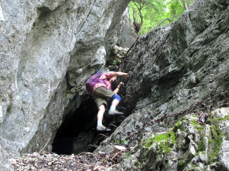
For the next half an hour, the path meanders its way up the cliff, from ledge to ledge. Some of this is a little exposed, but quite easy. Minor scrambles are assisted with iron work, and railings have been fixed along the more unnerving places. Eventually, you come to the Pas de la Mort itself - an ascent up a chimney assisted with chains, ladders, and iron rungs fastened into the rock. This follows the tree-lined rake which may be seen in the top left of the photograph. The whole section of path from the cave to the Pas de la Mort is good fun, and should be lingered over.
Once up the chimney (1280 m), the path continues to rise through the forest well above the valley, where you may spot a nineteenth century boundary stone which once marked the frontier between France and the Kingdom of Sardinia's Savoy territory, before starting to contour to the south. Some half an hour or so after leaving the Pas de la Mort, you meet the Tour de Chartreuse path coming in from the left (1490 m). Keep straight on. This whole area is a highly protected Nature Reserve, and is very beautiful.
After a further half an hour, the path enters open pastures, and you will soon see the col de Bellefont in the distance. The path climbs steadily through the pastures, with a cliff fairly close on your right. When these cliff give out, an old sign post is reached some 15 minutes after leaving the forest (1610 m). We now need to make our way up the ridge on the right, and follow what is at first a fairly thin path, but one which soon gains in confidence. This pleasant path makes its way steadily uphill through the forest, before meeting an open area, when it makes a steep beeline for the crest (1900 m), which is reached some fifty minutes after leaving the pasture below.
Just below the crest is the Roman Inscription itself, engraved into the rock, and picked out with red paint. It is reputed to date from the first or second century, and marked the boundary of the lands of the Aveien people. It is not difficult to reach the inscription by the way we are going to descend, but having a territory marker here implies that this was a major route over the crest 2,000 years ago. One is filled with admiration for those people who lived in these hills at that time.
The way on from the Roman Inscription is down the prominent cleft to the west. This 12 metre high chimney is steep, a little greasy, somewhat exposed, and requires care. A rope may be required for those who are lacking in confidence. The chimney starts as a confined, fairly muddy slope, but then becomes vertical. There are ample footholds, and you can lower yourself using some in-situ iron railings (photo).
Below the chimney, the path turns north, and for the next kilometre or so, spectacularly follows a steep grass terrace with high cliffs above, and enormous cliffs below. When seen from a distance, it is difficult to appreciate that a path could follow this line. It's a little airy, but easy enough, and very enjoyable. After a bit, it crosses the ridge a couple of times, before descending some loose scree on the west side of the crest some 30 minutes after leaving the chimney.
The main descent starts some 10 minutes later, when the path traverses the top of a subsidiary ridge. It then turns left, into a steep and loose descent down a narrow gully for some 200 metres - the Cheminée de Fontanieu. This requires great care. The end is heralded by a short steeper handrail section. Just below this, a cave in the north wall passes impressively right through the arrête into nothingness - a place to avoid! Below, the gully drops down a cliff, so the path crosses to the left hand side to complete its descent.
The path then ascends (the last thing that one needs at this stage of the walk!) beneath the cliffs to the south, with iron railings offering moral support in some of the more exposed places, soon to reach an easy grass terrace. After a few hundred metres, it turns back on itself and descends into the forest. Here you must take care not to lose the way. The main path contours through the forest to the south - we, however, must locate a steep path descending straight down to the col de Fontanieu, obscurely located a few metres after leaving the alp. This leads to an open pasture at the col (1480 m), and we turn right to follow a strike-slip fault valley back down to the meadows of the Cirque de St. Même.
With luck, the bar will be open, and you can enjoy a well-deserved beer.