
Tour of the Vallon des Emeindras
Starting point: le Sappey-en-Chartreuse Difficulty: 1 Ascent: 700 m Time: 5½ hrs Quality: ***
This is a circular walk away from the high tops, but nevertheless it is both interesting and worthwhile, exploring the area to the south-east of Chamechaude. It starts from le Sappey-en-Chartreuse, follows the GR9 to the Mont Eynard ridge overlooking Grenoble, and then follows the ridge for almost 5 km north-east to rejoin the GR9 at the attractive Emeindras le Dessus pastures. These dominate the watershed between Sappey and St. Hugues, and the separating ridge is followed along the GR9 onto the flanks of Chamechaude, and hence round to the Habert de Chamechaude. It is then followed back to Sappey and the car (map). Much of the walk is in the shade, so is particularly suitable for both very hot days, and also for those days when the high tops are in cloud.
We start from the large car park at le Mollard Giroud on the southern outskirts of Sappey-en-Chartreuse (1000 m, grid ref: UTM 31T 71801 50154). It is most easily approached from the north by taking the road just below the church.
From the car make for the north-east corner of the car park where a signpost for the GR9 will be found. Follow this down into the valley and over the stream where it turns right along a track. It skirts the Indian Forest adventure park and swings left onto a track which makes its way up a piste. To start with the piste is steep, but it eventually starts to traverse the slopes on the right. At the end of this section, pass under a cable to enter the forest. After another 50 metres we follow the GR9 up a track on the left. A few minutes later, just as the steep track starts to flatten out, the GR9 continues as a path on the left. This crosses another track and then almost immediately arrives on the ridge at Pré du Plat, 1330 m.
The hard work is now done, and we leave the GR9 to head north along the ridge on an unsignposted path which is followed for almost 5 km. Although mainly in forest, this very fine path has the occasional glimpse of the cliffs below the ridge, and dramatic views into the Grésivaudan valley 1000 m below from which rises a constant drone of traffic. After 50 minutes we pass the Pas de la Branche where a traditional path crossed the ridge. Alas, the pass is now orphaned - the commune stopped access from the east in 1986 due to the danger of stone fall, and more recently, forestry operations have obliterated large sections of the path on the west side.
From here the path is generally easy to follow, although it is possible to be led astray by fallen trees and find yourself too far below the ridge. If that is the case, just make your way back up. After an hour you pass a beautiful grassy knoll on the ridge with a survey point (1489 m) - a perfect place for lunch, with fine views in all directions.
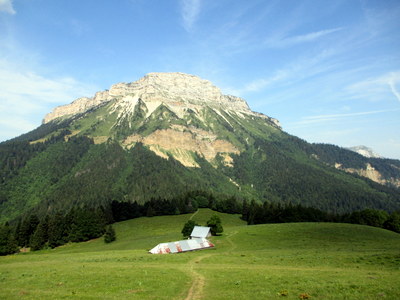
Twenty minutes from the knoll a fence is met with a way through it in a further 20 metres. Follow the fence uphill for five minutes to meet the GR9 at L'Emeindra de Dessus (1490 m). This is on the watershed between St. Hugues to the north and Sappey to the south. We now turn left down some beautiful meadows overlooked by Chamechaude, to the Chalet de l'Emeindra. This really is a sublime area. Another signpost is encountered near the habert, and we continue our line along the ridge following the GR9 in the direction of the Habert de Chamechaude, with a view down towards St. Hugues.
Re-entering the forest, we follow the path for less than 10 minutes down to the true col. From here, the path rises up Chamechaude beneath orange Jurassic cliffs before it starts to traverse south beneath pastures some 40 minutes later, with the white Cretaceous cliffs looming overhead. A further ten minutes sees the Habert de Chamechaude coming into view.
The Habert de Chamechaude is a fine building in an equally fine location, a little reminiscent of Heidi's grandfather's house on the alm. The first time we passed by, a mule and donkey, presumably used for moving goods up the hill, were grazing in the shade of the woods.
The descent begins next to the habert, and starts as a pleasant easily-graded path. After ten minutes a cross-roads is met, and we keep on the left track, picking up the path again on the right after 30 m. Over the next few minutes we cross the track a couple more times, before the path is absorbed by an old forest track which starts nicely, but soon becomes less easy going. Eventually we meet a road. Head straight across it towards la Charmette. This leads to the small hamlet of Jaillères where a fountain allows water bottles to be filled. Just past this a track continues down for 300 m to a road junction in Sappey. The car park is 100 m on the left.