
Bec Charvet from Col du Coq
Starting point: Col du Coq Difficulty: 1 Ascent: 300 m Time: 3½ hrs Quality: **
Positioned between the imposing Chamechaude to the south-west and Dent de Crolles to the north-east, Bec Charvet is easy to ignore, especially when based within the massif. From Martinière it has the impression of being a forest-covered lump without particular merit. From Manival, the village at its base in the Isère valley, however, it presents a totally different picture. A huge ravine has been incised into the Jurassic sediments, at the top of which its shapely peak overlooks cliffs several hundred metres high. The ravine boasts one of the largest debris flow torrents of the French pre-Alps, and it was once responsible for displacing the Isère river. To gain a full appreciation of the hill and the ravine, its ascent should really made from Manival, where a circuit can be made around the steep-sided valley. This walk, however, starts from the Col du Coq, and does a traverse of the summit pyramid. It is a lot shorter but is still worthwhile, and it does save the drive round when based within the massif.
The walk follows the GR9 south-west from the Col du Coq to the Col de la Faîta (also spelt "Faïta"), ascends the west ridge of Bec Charvet, and descends the east ridge, before returning easily back to the Col du Coq (map). There are no major difficulties, but it is best done in dry weather as there are some steep ascents on clay which become very slippery when wet.
We start from the Col du Coq. Follow the road down to the west to where there is a large clearing on the outside of the second major bend. The GR9 continues from the back of the clearing. It undulates its way round the flanks of the hill, mainly in forest, for about ¾ of an hour, until the ridge is reached at the Col de la Faîta. At one point, a newer track superimposes itself on the path, but the original path continues on the left after a hundred metres. At the col, we leave the GR9 which turns right downhill, and start our ascent to the left.
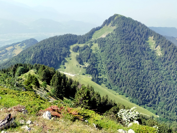
The path follows close to the ridge, mostly at an easy angle. Occasionally, it strays to the edge where one catches glimpses of the impressive cliffs of the south face. Once or twice steeper sections on clay have to be negotiated, which can be very slippery when wet. The vegetation morphs from forest to alpine, and then the path emerges onto a rounded grassy summit. The views from here are amazing, with the prow of Dent de Crolles to the north-east; Grand Som to the north; Chamechaude to the west, on which one can trace the path leading up to the Jardin; and the depths of the Manival valley to the south. It's a splendid place for lunch, although grass is the only available seat. It's also a popular feeding ground for alpine swifts, so don't be too disconcerted when they whistle past your ear at a rapid rate of knots.
There is no doubt about the way off - it's the only other path. It initially leads north towards the Grand Som, and soon enters the forests to make its way steadily downhill. There is one place where it is possible to go wrong, but not catastrophically so. Just after some limestone steps about four or five metres high, a path carries straight on. This is the most direct route back to the Col du Coq. However, to the right an indistinct path traverses towards a prairie glimpsed through the trees. There are some red on white waymarks on trees just above the route, and blue paint blobs on the ground. Once you reach the prairie, the path becomes obvious.
The prairie is a wonderful place. The views of Dent de Crolles are overwhelming, and when we last passed through, it was covered with a fine display of cornflowers and St. Bruno's lily, but the path is a little stony, and it pays not to get too distracted by the views and the flora. The path then re-enters the forest, and stays close to the ridge. In one place, the path bifurcates with red on white way markings on both branches. They go to the same place, but the one on the right stays closer to the ridge, and provides occasional views of the cliffs. After a while, the path crosses an old forest track. We turn left on to this to return to the Col du Coq after about a kilometre of easy walking.
It's a great little walk, and on a hill that is far less frequented than its more imposing neighbours.