
Grande Sure: Les Echelles de Charminelle
Starting point: Préfenton Difficulty: 3 Ascent: 600 m Time: 5 hrs Quality: ***
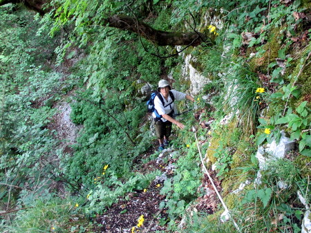
This is a walk for Chartreuse aficionados. The ascent follows an old chamois hunters route (map) through the cliffs above the Roize Torrent, and makes use of four rather dodgy iron ladders which have been installed on some vertical steps, apparently way back in 1910. As it doesn't get very high (about 1260 metres), it is suitable for days when the clouds are on the tops, and because it is mostly in forest, it is also suitable for days when it is very hot. It is classed as Grade 3 in difficulty on account of the steep exposed ground between the ladders, and because the route finding requires great care. All the scrambling, however, is easy.
The car can be parked off the road at Préfenton, just below the Chemin du Clos (590 m, grid ref. UTM 31T 70847 50209). This is approached from Pommiers-la Placette, a small village between Voreppe and St. Laurent-du-Pont.
From the car, follow the road up and take the track passing below a couple of houses. After less than a quarter an hour, the path goes through a hay field with a fine barn, and shortly after the main path, by which we will be returning, goes off to the right. Our path goes to the left, and this rises steadily through the forest, gradually metamorphosing from a track into a thin trace. It then starts on a rising traverse above steep slopes, crossing a couple of gullies en route. A little less than an hour after leaving the car, a cable-assisted rocky ledge is traversed, which leads round a corner to some fine views of the cliffs on the other side of the Roize. From here, the way marking becomes a lot clearer. A short scramble and some steep slopes are crossed before swinging to the left and rising to a cliff. This is followed round to a promontory with views of the Vercors and Isère valley.
The first ladder, about 4 metres high, is reached some 20 minutes after leaving the cables. This one is particularly twisted and warped, and like the others, it is not secured at the top. Nevertheless, they are all quite safe if treated with respect. The following two follow rapidly in succession, with some exposed scrambling and traversing between them. The last is actually in three sections. Once up the third, the difficulties start to ease off. A horizontal path leads back towards the Roize across some steep slopes where you should keep an eye open for the yellow flashes marking the route. After 10 minutes it rises towards some cliffs, where the fourth ladder will be found. Above this a short traverse on the right leads to a good path, which in turn leads to the main path between the Monastère de Chalais and the Prairie de Charminelle, reached a couple of hours or so after leaving the car. Turn right towards the monastery.
The next section is an absolute delight. The sound of a river will soon be heard, and before long the path is running above the Charminelle stream. This is a superb section of path, with some wonderful flowers. It soon drops down to the stream which is crossed adjacent to a splendid waterfall with tufa covered walls. The stream disappears from sight, and the path crosses a subsidiary stream, which drops steeply into a gorge, and follows a narrow protected path, from which there are dramatic views of the Charminelle stream plunging some 100 metres or so into the same gorge. Once beyond this, 20 minutes of easy going leads to a junction with a forestry track at the Abri de la Roize, another small unwardened refuge. Heading across to the picnic area, a path will be found that descends to the Monastère de Chalais in about a quarter of an hour.
Here will be found a signpost. Follow the path back towards Pommiers-la-Placette, which crosses the road a couple of times. One section where it has been 'improved' by a utility company is a little brutal underfoot, but it doesn't last long. After half an hour look out for a track going off to the right - it is sign-posted, but the sign post is on the other side of the track and not at all obvious. After a few minutes, we turn right again at a second junction to follow a path that traverses a long way up the river to a crossing point, and then back on the other side to reach the ascent path after about half an hour. A further 10 minutes sees us back at the car, after a very satisfying walk