
Dent de Crolles - Pas de Terraux
Starting point: Piste de la Gorgette Difficulty: 2 Ascent: 550 m Time: 4 hrs Quality: ***
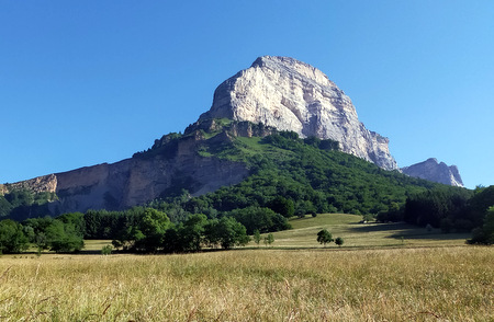
This half-day expedition explores the area under the southern pillar of Dent de Crolles, and covers a satisfying circuit (map) which has some spectacular views. The first half of the walk follows the Tour des Petites Roches which runs along the wooded eastern flanks of Dent de Crolles, and is very straightforward. The return, however, takes a line under the eastern cliffs of Dent de Crolles, and one kilometre-long section is quite airy and sustained, and for that reason it has been given a Difficulty 2.
The walk should logically start from Neyroud, a small hamlet to the south of Dent de Crolles which is the lowest point, but parking is not easy there, and it is more convenient to start from half-way down: from la Piste de la Gorgette which is about 650 m to the east of the col du Coq, where there is plenty of parking (1215 m, grid ref. UTM 31T 72311 50198).
From the car park, follow the prominent track leading north-east for about five minutes, and take the path leading off down the hill towards Neroud. This isn't sign-posted, but the path is waymarked with yellow blazes. This path is quite steep, and is probably best got over whilst the knees are still fresh. After 15 minutes it passes a junction at les Civières, where we turn left, and in a further 10 minutes the path crosses the ravine next to a rather ugly concrete wall designed to hold back flood debris. This more-or-less marks the lowest point of the walk. The path now levels out and passes some wonderful views of the south pillar of Dent de Crolles on one side, and views down to le Tournoud with its church on the other. Ignore a couple of paths to the right.
Some 40 minutes after leaving the car, we arrive at les Neyroud - a cosy hamlet in a wonderful location under the nose of Dent de Crolles. Take a well-signed road to the left, and it morphs into a stony track which crosses a stream bed and ascends alongside it. Soon it levels out and starts to traverse along the flank of the hill. After half an hour of very pleasant and easy going a junction is reached at Bois de Frettes where a path heads off down to the medical centres. We keep along the Tour de Petites Roches, which immediately ascends some zig-zags to a higher level. This eventually arrives at another major junction where a vehicle track crosses the path. Our way is to turn left up the track to the Cabane du Berger - a great place for a second breakfast. There has been a lot of work put into the slopes above to control avalanches, and just beyond the cabane is a massif structure looking for all the world like a Franco-Incan ruin - which is presumable intended to divert avalanches.
The next section of the walk is superb - passing through flowery alps, beneath the massif ramparts of the east face of Dent de Crolles, where in all likelihood you will be honoured by the company of chamois. The path from the cabane starts as a flowery track, but soon morphs into a thin path that meanders its way up towards the cliffs in a southerly direction. Once there, it follows a clear, but on occasion an exposed line as it negotiate an occasional gully, at the foot of the cliffs.
Forty-five minutes after leaving the cabane, we pass a loose path going up to the entrances of Grotte Annette Bouchacourt and Grotte Chevalier - two of the entrances into the 60 km-long Dent de Crolles cave system. A few minutes beyond this, the path traverses across the Hauterivian marls, that lie at the base of the limestone, using sloping ledges. The route across these is made unambiguous by some fixed ropes, put in place by commercial cave guiding companies for the benefit of their clients. The ledges finish at the end of the south pillar of Dent de Crolles, which one rounds to be confronted by views across to Bec Charvet and Chamechaude beyond. This really is a stunning place, although you should be aware of the risk of stones falling from the cliffs in this area. They do give fair warning by whistling at you during their descent.
From the corner, the route becomes clearer as it makes its way across the debris from a major rockfall that occurred in 2010, towards the rotting, yellow Ravine de la Gorgette. The upper slopes of this are delicately traversed, and care is required in one or two places where the path is nominal.
Once out of the ravine we set off down the pasture alongside it, taking time to admire the views behind us, as well as those in front. At the bottom of the pasture, we meet a path where we turn left to make our down through the forest back to the car.