
Grand Som from la Correrie
Starting point: la Correrie Difficulty: 2 Ascent: 1270 m Time: 7 hrs Quality: ***
This walk ascends Grand Som from the west (map). It ascends the western flanks above the monastery, traverses the summit ridge, and descends from the head of the St. Bruno valley, which is followed back to the car. The time assumes the full round trip. It is the classic route on Grand Som, and if you have time for just one ascent of the mountain, it should be by this route.
La Correrie may be found by following the D520b from St. Pierre de Chartreuse towards St. Laurent du Pont for 3 or 4 km, and turning right up the St. Bruno valley towards the monastery. This road loops round back to the museum, where a parking area made available for walkers may be found at the back (850 m, grid ref. UTM 31T 71863 50257).
This traditional route up towards the Grand Som has been de-emphasised by the Regional Nature Park, so care should be taken to ensure finding the right way. Take the path at the back of the car park, ignoring the track that ascends immediately to the left. We need to follow this for about 50 minutes along a variety of old paths, new paths, and forestry tracks, following the yellow and red waymarks. After 45 minutes or so, the route, which is following an old section of path at this stage, turns round a gully, and veers between some large boulders. Shortly beyond this, a path may be found on the right, heading up and back, marked with an orange blob. This is the way up to the col du Frenay, and is the all-important junction.
Turn up the new path, which ascends easily in a series of sweeping zig zags, to arrive on the ridge after about an hour. Here, you will need to negotiate some fallen trees (2014). From the ridge, follow the path round to the left, and after a few minutes you'll pass the way down to la Coche on the right.
The true col du Frenay (1580 m) is reached in ten minutes, and after a further five minutes or so, the path crosses to the west of the ridge, to continue its ascent beneath limestone cliffs. Marmots abound here; their burrows lie alongside the path, and they can be heard screaming their warnings from their rocky vantage points. Near the top of the scree the path swings round to the right, across a system of ledges, and up some small crags as it rises once again to the ridge. There is some exposure here, and the use of hands is required. The col at the top is known as la Suiffière (1798 m).
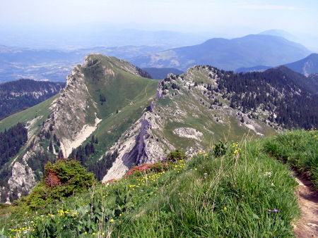
From here, there are two routes to the summit. If you have a reasonable head for heights, and conditions are dry, you can follow an exhilarating scramble along the ridge (Grade 2), which makes an uncompromising bee-line for the summit.
The other route drops down a few metres from the ridge, and then traverses pleasantly across the rocky flanks of the hillside. The flora in this area is outstanding. Twenty minutes after leaving the ridge, you meet a path coming up from the right, which is the route down towards the col du Coucheron. The path then enters a rocky gully, and when it exits, ascends the steep flank to the summit cross, which is reached some 45 minutes after leaving the ridge. It has taken us about 3½ hours to reach this point from the car park.
The summit is a good place for lunch. As you would expect, the views are superb, and below, to the south-west, you can see the monastery nestling in the secluded St. Bruno valley. Unfortunately, the summit is now the home of a very naff viewpoint station consisting of two halves of a concrete Chartreuse.
This walk is a round trip, so from the summit, continue along the ridge - which is well adorned with rock gardens. After 15 minutes, the path divides. Either path will do, but the lower path follows the Sangle des Moutons - a grassy terrace between the cliffs which passes through some nice rock scenery. There are some iron cables in places, but the protection they offer is not really required. One interesting feature is that for some distance it follows the line of the of the hanging-wall of one of the major Chartreuse thrust faults.
The two paths meet up after 20 minutes, and the combined route heads down towards the col du Bovinant (1645 m) reached after a further 15 minutes. Turning left down the valley reaches a water source at the shepherd's cabin - a good place to fill water bottles.
The path now makes its way steadily down into the St. Bruno valley. It passes a number of junctions, but the way down is always obvious. The path passes a chapel near the valley floor, becomes a road with hard core chippings, and before long the monastery comes into view. It has taken a couple of hours to reach this point from the summit.
Follow the track behind the monastery which rises through the woods to eventually link up with a forest track which lands you back at the car park some three hours after leaving the summit.