
Dent de Crolles - A Visit to the Grotte Chevalier
Starting point: Col du Coq Difficulty: 3 Ascent: 250 m Time: 4 hrs Quality: ***
Warning: The local cave rescue organisation have reported that the entrance to Grotte Chevalier is currently prone to blockage, being down a frost-shattered scree slope. If the way in is not evident, then keep out. If you do venture in, ensure that you carefully take note of exactly where the exit is on the wide scree slope.
This expedition is for the young at heart, and the agile, and has as its target the inner depths of the spectacular Grotte Chevalier. Chevalier was the leader of the team that undertook the main explorations of the Dent de Crolles caves during the war. The cave that is named after him was always obviously very much part of the main cave system, but was only recently connect to it. The time is for the ascent and descent, and allows for a full exploration of the cave.
This half day expedition starts with an exciting traverse under the summit cliffs of the Dent de Crolles, and has as its climax, a trip deep into the heart of the mountain.
The route to the cave is exposed, and should be avoided if you feel uncomfortable in such conditions. The cave is fairly long, but safe provided a few basic precautions are taken. A minimum of three people should descend, one of whom should be experienced in caving, and all of whom should be equipped with some head protection (a balaclava will do), a warm jersey, and most importantly, a head lamp (preferably of the Petzl variety), and at least one spare torch. Unlike most caves, there is no risk of getting muddy or wet. It is also useful to take some fluid, as such dry caves can be very dehydrating.
The Chevalier is located immediately under the summit cliffs, in the eastern face (map). Park at the top of the col du Coq (1434 m grid ref. UTM 31T 72238 50205), and follow a path through the woods towards the Dent de Crolles (it divides after a few metres - keep to the right). This take you onto the pastures beneath the impressive summit cliffs. which are are a riot of colour in the spring. Follow the track up to the col des Ayes (1538 m), reached some 20 minutes after leaving the car.
From here follow the zigzags up the pastures, until about 20 metres above the turn off to the Trou du Glaz. Here, look for a thin line crossing a shallow scree gully on the left. Follow this, and on the other side an obvious path starts a gentle ascending traverse of the hill. At times, the path is obscure, and divides - however, just keep an eye open for the main line. This eventually meets a very prominent path running down the Ravine de la Gorgette - a yellow, decaying feature. This is the start of the Pas des Terreaux. Enter the ravine, and follow the obvious route that traverses round its head. Care is required, as the path is a little nominal at times. On the far side, the path eases as it approaches the nose of the South Pillar. This section was subject to a massive rockfall in October 2010 which took out 150 m of path, so be warned! The most impressive section is after the path rounds the nose of the cliff, where you will be traversing on shale ledges. You should listen out for stones falling from the cliffs, all along this path. They do give fair warning by whistling at you during their descent. This part of the rope is usually protected with a handline.
From the nose, follow the path round for a couple of hundred metres. The Chevalier is on a platform 30 metres or so above the traverse, and is accessed by a thin ascending path through the loose scree and vegetation. Local commercial caving groups sometimes leave fixed ropes on the route.
The grotte Chevalier is in a very loose frost-shattered area of cliff, where there is no real room to sit down and have lunch. Traversing back under the cliffs at the same level for a hundred metres or so, however, leads to a platform in front of the grotte Annette, named after Annette Bouchacourt, one of Chevalier's team who was killed in a skiing accident. This provided the original connection with the main Dent de Crolles system. However, be warned: the Annette should be avoided for casual exploration, as the entrance passage leads to a scree funnel which is is liable to slumping, and the route beyond is not straight forward, and becomes somewhat technical. The platform, though, is a perfect place for a picnic, with excellent views into the valley below, and the Belledonne hills opposite.
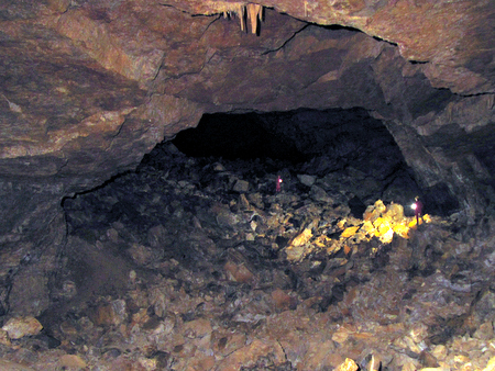
If you do wish to explore the caves a little further and have the equipment listed above, you should return to the Chevalier. The entrance descends steeply down loose frost-shattered scree, and care should be taken not to bang your head. At the bottom of the slope is a little clamber over a boulder onto a continuation of the slope which debouches into the main passage proper. A traverse line descends the slope, and then turns back on itself to reach its base. At this point, look around very carefully, and note the route you have come, as daylight cannot be seen from here. A couple of small but prominent cairns could be constructed to guide you back up the slope.
You are now in the cave proper. This starts with the generous dimensions of about 4 metres wide, by about the same high, but a couple of hundred metres in, the passage becomes overwhelmingly huge - thirty metres wide, by 10 metres high. Traversing this passage is slow, having to negotiate large blocks that have fallen in from the roof, and it drops fairly steadily. It continues thus for three quarters of a kilometre into the heart of the mountain, reaching a depth of 160 metres below the entrance, until it somewhat anticlimactically finishing in a blank wall. By this time you have traversed over a third of the distance to the Guiers Mort at the head of the Perquelin valley, and have some 400 m of rock above your ahead. However, the cave does connect with the rest of the Dent de Crolles system, and if you're lucky you may see some cavers appear from the roof, abseiling down a 25 m shaft near the end, having traversed through from the Trou du Glaz.
Unfortunately, the cave is totally devoid of stalagmitic decoration, but early in the season, impressive ice formations may be found.
The journey out is somewhat hot and tiring, but navigation is not too much of a problem in that fluorescent guiding markers, visible for a considerable distance, keep you on route. At the start of the entrance slope, remind yourself of the route back to the boulder guarding the entrance, and make your way up the scree to it. At the top of this you will see welcome daylight having descended into the heart of the mountain.